Hostería Chukirawa es uno de los primeros sitios de alojamiento autorizados por el Ministerio de Turismo en Quilotoa. Desde 2008
Quilotoa Loop: The Complete Guide to Ecuador’s Most Unforgettable Trek
The Quilotoa Loop doesn’t appear on many lists of the world’s most famous treks. That’s about to change — and those who do it before it gets crowded will be glad they did.
It’s a 3 to 5-day trekking route through the Ecuadorian Andes connecting indigenous Kichwa communities across canyons, páramo highlands and trails that don’t show up on Google Maps. No crowds, no aggressive tourist infrastructure, nothing standing between you and one of the most raw and honest landscapes in South America.
And it ends at a volcanic lake that looks like it belongs on another planet.
This is the guide you need before you go.
What is the Quilotoa Loop
The Quilotoa Loop is an approximately 35-kilometer hiking route in the Cotopaxi province of Ecuador. It connects the villages of Sigchos, Isinliví, Chugchilán and Quilotoa through ancient Andean trails used by Kichwa communities for centuries.
What sets the Quilotoa Loop apart from other treks in South America isn’t technical difficulty or extreme altitude. It’s the combination of three things that rarely appear together: unfiltered Andean scenery, living indigenous culture and a finale — the Quilotoa crater lake — that no other trek in Ecuador can match.
Not the longest trek. Not the most technical. The one most travelers never forget.
How Many Days Do You Need for the Quilotoa Loop
Minimum 3 days. But if you can, take 4 or 5.
With 3 days you’ll make it to the end of the Quilotoa Loop, yes — but with little room to stop when the landscape calls for it, and it will. With 4 days the pace is right: each stage has space to breathe and you arrive at Quilotoa with energy to spare. With 5 days you have an extra day for the crater rim trek — the hike that turns a great experience into an extraordinary one.
The Quilotoa Loop Route: Stage by Stage
Stage 1 — Sigchos → Isinliví
~14 km | 5–6 hours | Moderate difficulty
The Quilotoa Loop begins in Sigchos, about 4 hours from Quito by bus. From here the trail starts through terraced farmland and ravines that descend toward the Toachi canyon. This is the warm-up stage — the landscape opens gradually and your body begins to grasp the scale of what lies ahead.
Isinliví is the first village: small, authentic, with the direct and unpretentious hospitality of Andean communities. From Quito, take a bus to Latacunga (1h30) and another to Sigchos (2h30) to begin the route.
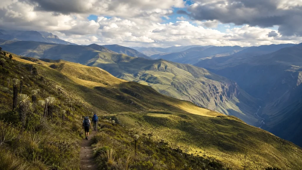
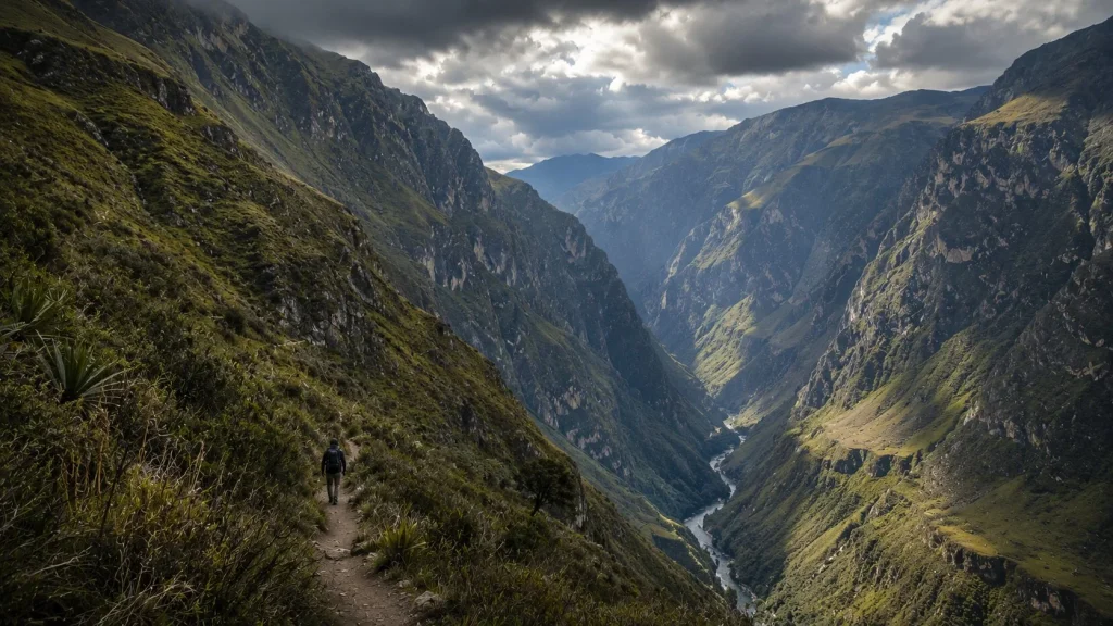
Stage 2 — Isinliví → Chugchilán
~12 km | 5–6 hours | High difficulty
The most demanding stage of the Quilotoa Loop and, for many, the most memorable. The trail descends to the bottom of the Toachi river canyon — a steep drop that tests your knees — then climbs toward Chugchilán with the canyon open below and the páramo above.
The kind of tired that feels earned.
Chugchilán is the heart of the loop: a village that at first glance seems to have nothing, and ends up being the favorite of many travelers.
Stage 3 — Chugchilán → Quilotoa
~9 km | 4–5 hours | Moderate difficulty
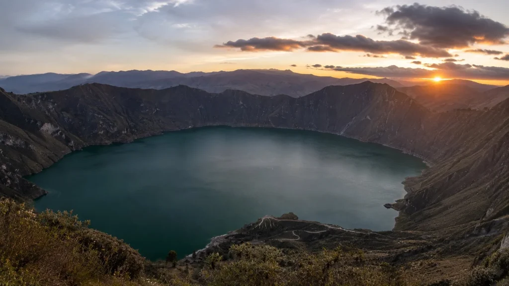
The last day of the Quilotoa Loop is the shortest in kilometers and the longest in impact. The trail climbs gradually toward the Quilotoa volcano. There’s no sign of what’s coming until suddenly, without warning, the crater appears on the horizon.
Three kilometers of volcanic lake. Turquoise water at 3,914 meters above sea level. The ending that justifies every hour of the stages before it.
And steps from the crater rim, Hostería Chukirawa — the natural finish line of the loop and the place where the journey ends right.
Why Finish the Quilotoa Loop at Hostería Chukirawa
Arriving at the end of the Quilotoa Loop after days of hiking deserves more than just any room.
Hostería Chukirawa sits in the village of Quilotoa, steps from the crater entrance. A heated bed for cold Andean nights, a dinner made with local ingredients prepared for someone who just spent days on the trail, and a dawn near the lake reserved for those who slept here.
Staying an extra night also lets you do the crater rim trek the next day — 4 to 6 hours along the edge of the volcano with 360° views over the lake and the Andes. The experience very few tourists complete and that for many ends up being the highlight of the entire trip.

June: The Best Time to Hike the Quilotoa Loop
You can hike the Quilotoa Loop any time of year. But June has something the other months don’t.
It’s the start of the dry season in the Andes — clearer skies, less rain, the best conditions of the year for hiking and for seeing the lake. And June also brings the Inti Raymi.
The Inti Raymi — Festival of the Sun in Kichwa — is celebrated between June 21 and 24 in indigenous communities throughout the Ecuadorian highlands. Purification rituals, traditional dances, Andean music and a collective energy that exists at no other time of year. It’s not organized for tourists — it’s a living celebration practiced by the same Kichwa communities that inhabit the villages of the Quilotoa Loop.
Finishing the loop in Quilotoa during the Inti Raymi, with the volcanic lake as a backdrop and the communities celebrating around you, is an experience very few destinations in the world can offer.
The Quilotoa Loop Ends. Quilotoa Begins.
Days walking through the Ecuadorian Andes. Canyons, páramo, villages that mass tourism hasn’t found yet. And at the end, a volcano with a color-shifting lake inside.
The Quilotoa Loop is one of those routes that doesn’t translate well into words. You have to walk it.
And when you reach the end, Hostería Chukirawa is there — steps from the crater, dinner ready and a dawn near the lake for those who stay.
📍 Reservations: quilotoa.ec
Quick Facts
| Duration | 3 to 5 days |
| Total distance | ~35 km |
| Maximum altitude | 3,914 m / 12,841 ft (Quilotoa) |
| Difficulty | Moderate–High |
| Starting point | Sigchos (4h from Quito by bus) |
| Finish point | Quilotoa — Hostería Chukirawa |
| Best season | June–September |
| What to bring | Layered clothing, rain jacket, trekking boots, sunscreen, cash |
| Guide | Not required — guidance available at Chukirawa |
| Cash | Withdraw in Latacunga. No ATMs along the route |


